Earth3D: Unterschied zwischen den Versionen
GISWiki - Das freie Portal für Geoinformatik (GIS)
HeinzJ (Diskussion | Beiträge) |
HeinzJ (Diskussion | Beiträge) |
||
| (3 dazwischenliegende Versionen desselben Benutzers werden nicht angezeigt) | |||
| Zeile 9: | Zeile 9: | ||
* http://www.earth3d.org/ | * http://www.earth3d.org/ | ||
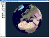
| − | http://www.earth3d.org/images/screenshot_landsat_europe_small.jpg | + | {| |
| + | |http://www.earth3d.org/images/screenshot_landsat_europe_small.jpg | ||
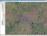
| + | |http://www.earth3d.org/images/screenshot_landsat_berlin_small.jpg | ||
| + | |} | ||
| + | |||
| + | |||
[[Kategorie:Programmierung]] | [[Kategorie:Programmierung]] | ||
Aktuelle Version vom 16. November 2005, 00:31 Uhr
Earth3D is a Earth viewer, for elevation and imagery, streaming from its own online database of mostly MODIS data, written by Dominique Andre Gunia of Braunschweig University of Technology
- portable open source (GPL), source is C++ and uses QT
- binaries available for Linux, MacOSX and Windows
- tried the Windows binary v1.0.1 (on 2004.09) and found:
- Although the program works fairly well, there was a lack of caching - turning left then right again would cause all the data to have to be streamed down again. The elevation dataset was also very strange (cruder than SRTM or even GTOPO).
- Apparently, to view any data besides the built-in dataset, one would need to modify the code.
| http://www.earth3d.org/images/screenshot_landsat_europe_small.jpg | http://www.earth3d.org/images/screenshot_landsat_berlin_small.jpg |